This is a favorite mountain for local and foreign mountaineers. The average temperature in its top is around 15 grade Celsius during the day, of course in the night, it’s biting cold. The magnificent Merbabu is in the middle of Central Java Province, comes from the word "Meru" means mountain and "Babu" means female or lady.
For years it has been known as a sleeping mountain, but in fact it has 5 calderas, namely:
Condrodimuko, Kombang, Kendang, Rebab & Sambernyowo. Mt. Merbabu last eruption was in 1968 which caused a lot of erosion. Usually it gives a tranquile atmosphere to its green beautiful environment.
Mountaineering Routes:
There are 2 routes to the summit i.e. From the North thru village of Tekelan’ Salatiga and the South route is thru Selo village, Boyolali.
The North Route
The nearest town is Salatiga. It’s about one hour drive from Semarang or Surakarta. The bus fee from both city to Salatiga is Rp. 2.000,- (The exchange rate of October 1, 1998 is US$ 1 = Rps. 11.000,-)
From Yogyakarta it’s about 2 hours by bus, the fee is Rp. 3.000,-
 From Salatiga take another bus to Kopeng resort. It costs Rp. 1.000,- then walk or take ‘an ojek’ (motor bike Taxi) for Rp. 2.000,- - to the village base camp:
Register to Arie Wijaya A.Md (or Bapak Sunaryo) the fee is Rp. 750,-. Guide fee to the peak and return again in the same base camp is Rp. 25.000,-
The address is:
POSKO MERBABU
Tekelan No. 96, Kopeng
Salatiga 50774
Central Java.
The base camp has a capacity to accommodate about 450 people. It provides modest bathrooms and worship houses: Mosque, Church and Vihara. There is a clear mountaineering route to the top, safety and supervision is conducted by Perhutani (Forest Authority) of Kopeng.
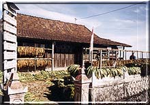 The village of Tekelan daily temperature is around 19 grade of Celsius. In this village live peacefully its inhabitans of 688 persons. They are traditional farmers growing vegetables such as onions, tomatoes, cabbages, carrots and also tobacco. The name of the village comes from the founder and ancestor of the villagers-mbah (grand father) Thekel, where his graveyard is in the village Cemetery. Tekelan village has a good reputation, it has a grammar school and groups of arts such as: KETOPRAK-traditional drama with gamelan accompaniment, Javanese dance of warriors, musical orchestra etc.
Up to present date they stick to their old tradition, they live in harmony and helping each other (gotong royong). Some little girls (until the age of 4 years old) are with uncombed and uncutted loose hair (rambut Gimbal) it is believed to free them from evil temptation and to be in safety. The cleaning of the hair must be done in ritual, lead by an "old" man. The springs in village are considered sacred and should not be bothered.
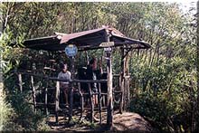
The Climbing
Note: The water springs are found nearby base camp, shelter Pending and nearby the 5 craters.
- The last village on the North slope, Tekelan is 1596 M.
From Kopeng is 1,8 Km by walking or 3,5 Km by motorbike. From Arie Widjaja’s basecamp walk about 1 hour thru the garden to shelter Pending (1800 m)
- Then walk another 1,5 hours to shelter 1-Gumuk (2260 m)
After crossing a small river (Kethekan), (a spring is found here) and passing a deep ravine (Pereng Putih 2200 m). In this area grows small bamboo trees which are used by locals to produce bamboo-crafts.
- Climb further 1 hour to shelter II Lempong Sampan (2450 m) thru a forest. There a 2 routes.
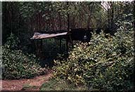
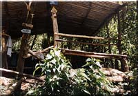
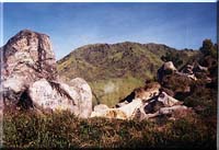
- From shelter II to shelter III about 1 hour walk – Watu Gubug (stony hut) (2610 m). There are 3 routes, with their own specific forest panorama. Some beautiful hairy flowers are growing attractively here The Watu Gubug are big stones with a hole as big as cave which could give shelter to 100 people. It is considered as sacred place. The climbers are advised behave accordingly. Do not urinate nearby Watu Gubug or the crater Condrodimuko. Do not put feet into the crater’s water spring.
- Climb another 45 minutes to shelter IV-Gunung/Mount Watu Tulis – 2896 m.
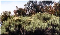 The view from here is quite amazing. The climbers can see several summits of Merbabu. From shelter III up to summits is green savannah with some beautiful mountain trees and flowers: acacia, Kemlandingan, Strawberry, orchid and of course the famous breath-taking Edelweiss. From time to time, the climbers shall encounter a group of various singing birds, jungle fowls, monkeys, deers and be careful of ....... Tigers. There is a radio communication here.
- Go forward to shelter V-(2898 m) for another 30 minutes from shelter IV. This place is surrounded by the magnificent summits of Merbabu. About 150 m from here are the dead-craters, there is spring nearby. To the right, there is Gunung (Mount) Kukusan (2928 m).
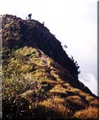
- Now, this is the heaviest trek, the so-called 627 m long "Jembatan Setan" – The Satanic Bridge, normally it takes 45 minutes to pass. There are deep ravine on the right and left side, until a place locally called Plawangan Ondorante (a crossroad to last summits).
- The Peak of Pregodalem (3119 m)
According to legend, there was a house in this peak, guarded by Kyai Syarif and mbah (grand-pa) Kerto. That’s why this peak is also called: Syarif or Kerto.
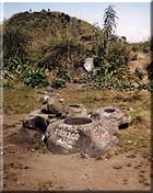
- The Peak of Kenteng Songo (3142 m)
From the crossroad, climb another 45 minutes, and here it is, the highest peak by the name of Kenteng Songo. Three are 9 stones in the form of mortar for pounding rice. Some believe, this peak is the "unseen" resident of a couple of ascetics by the name of Kyai and Nyai Rogodewo (body of god).
The picturesque natural view lures climbers to remain here for quite a long time. To the west are the blue summits of Sumbing and Sindoro, just a ‘few meters’ to the south is the aggressive Mt. Merapi. To the North are green and peaceful mounts Telomoyo and Ungaran. Mt. Lawu is standing pridely in the South-East
In the month of Suro (in the night of Javanese new year), the inhabitants living in the North Slope of Merbabu, make traditional offering in the craters of Merbabu.
From The South Route
Bus fee from Semarang to Boyolali Rp. 2.500,-
Bus fee from Solo to Boyolali Rp. 1.500,-
Bus fee from Yogya to Boyolali Rp. 2.000,-
Bus fee from Boyolali to Selo Rp. 1.000,-
Selo village is situated between Mt. Merbabu & Mt. Merapi.
In Selo, there are some inns.
- From Pasar (Market) of Selo, walk to the village bordering with the forest. Find the house/base camp belonged to Pak Sunarto. There is modest bathroom, mosque and a warung (small shop). In the Javanese month of Sapar, there is a ritual ceremony, the villagers give a traditional offering in the spring, as it provided a good life to them.
- Climbing from this side, the climbers can always see the beautiful view of Mt. Merapi and Mt. Lawu on their back.
From shelter I-Balong, shelter II-Pentur and shelter III. The climbers can walk leisurely under the shadow of big forest trees. The name of Balong according to local legend, is to remember Eyang (grand-pa) Citranala conquered a tiger. In that fight, his cloth was holed by the tigers’ bite (cloth=gombal; hole= bolong; gombal bolong, the abbreviation is Balong)
From shelter IV up to summit, there are savannah and some flowers like a special kind of Edelweiss, named The Snowy Edelweiss. The most Tiring trek is the climbing to this shelter.
The shelter V is the peak of Kentong Songo. The climbing from the south route takes around 6 hours time.
It is advised to the mountaineers, the best way is to climb Mt. Merbabu from the North, Tekelan village and descend in Selo. Afterwards, depends to availability of time and energy, climb over Mount Merapi.